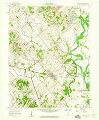
1958 Map of Wheatland
USGS Topo · Published 1959About this map
The Baltimore and Ohio railroad corridor anchors this late 1950s landscape, serving as a vital industrial artery through Steen and Washington townships. The town of Wheatland sits at the intersection of this rail line and local thoroughfares, flanked by a complex drainage network including Opossum Branch and Nicholson Pond. The presence of a Mine Dump and Mine Pond near the rail line suggests the localized extraction activities that once supported the regional economy.
Find a feature on this map
33 named features on this map. Tap any name to fly to it.
Don’t see what you’re looking for? This feature index may not catch every label — zoom into the map to look around manually.
Map Details
Editions of this 1958 Wheatland Map
3 editions found
Other maps of this area

1942 · Fritchton
USGS Topo · 1:24,000

1943 · Oaktown
USGS Topo · 1:24,000

1943 · Bicknell
USGS Topo · 1:24,000

1943 · Plainville
USGS Topo · 1:24,000

1944 · Fritchton
USGS Topo · 1:24,000

1944 · Washington
USGS Topo · 1:24,000

1944 · Monroe City
USGS Topo · 1:24,000

1944 · Wheatland
USGS Topo · 1:24,000

1944 · Iona
USGS Topo · 1:24,000

1945 · Sandy Hook
USGS Topo · 1:24,000