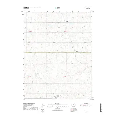
2018 Map of Wheaton
USGS Topo · Published 2018About this map
Wheaton sits at the southern edge of this modern survey, where a tight grid of streets including Main St and North St meets the section-line roads of the Kansas prairie. The landscape is defined by the drainage of the Clear Fork, which feeds a network of smaller streams like Irish Cr and Dutch Cr. This area on the border of Marshall and Pottawatomie counties preserves a distinct rural character centered around small crossroads and historical religious sites. Genealogists will find significant value in the documentation of several local burial grounds, including Saint Josephs Catholic Cem and Saint Luke Lutheran North Cem, as well as smaller settlements like Lillis and Nolan. The map traces the persistent agricultural road network, such as Parallel Rd and Golden Belt Rd, that has shaped the region's movement for generations.
Find a feature on this map
48 named features on this map. Tap any name to fly to it.
Don’t see what you’re looking for? This feature index may not catch every label — zoom into the map to look around manually.
Map Details
Editions of this 2018 Wheaton Map
This is the sole edition of this map. No revisions or reprints were ever made.
Other maps of this area

1889 · Seneca
USGS Topo · 1:125,000

1889 · Wamego
USGS Topo · 1:125,000

1894 · Seneca
USGS Topo · 1:125,000

1894 · Wamego
USGS Topo · 1:125,000

1955 · Manhattan
USGS Topo · 1:250,000

1956 · Manhattan
USGS Topo · 1:250,000

1957 · Manhattan
USGS Topo · 1:250,000
1964 · Westmoreland
USGS Topo · 1:24,000
1964 · Onaga
USGS Topo · 1:24,000
1964 · Westmoreland NE
USGS Topo · 1:24,000