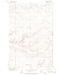
1956 Map of Wheeler NE
USGS Topo · Published 1957About this map
Washington-Grant County borderlands are defined by the stark, etched drainage patterns of the Columbia Plateau in the mid-1950s. The landscape is dominated by the broad course of Rocky Coulee and its tributary Rocky Branch, which carve through the high basalt plateau. Human activity is concentrated along the southern rail corridor where the Chicago Milwaukee St Paul and Pacific railroad traverses the coulee floor. This infrastructure supported small outposts like Ruff, a point of transit in an otherwise spare agricultural and ranching region. The presence of the Schultz Memorial Cem and scattered Gravel Pits suggests the localized nature of early settlement and resource extraction. Significant elevation points such as Vabm 1653 and Vabm 1445 provide vantage points over the dry coulee systems, including Sand Coulee in the north.
Find a feature on this map
13 named features on this map. Tap any name to fly to it.
Don’t see what you’re looking for? This feature index may not catch every label — zoom into the map to look around manually.
Map Details
Editions of this 1956 Wheeler NE Map
2 editions found
Other maps of this area

1923 · Wheeler
USGS Topo · 1:62,500

1925 · Wheeler
USGS Topo · 1:62,500

1925 · Schrag
USGS Topo · 1:62,500

1953 · Ritzville
USGS Topo · 1:250,000

1956 · Wheeler
USGS Topo · 1:24,000

1956 · Wilson Creek SW
USGS Topo · 1:24,000
1956 · Bassett Junction
USGS Topo · 1:24,000

1956 · Wheeler NE
USGS Topo · 1:24,000

1956 · Wilson Creek SE
USGS Topo · 1:24,000

1956 · Wilson Creek
USGS Topo · 1:62,500