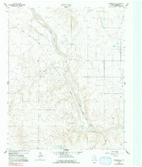
1962 Map of Wheeler SE
USGS Topo · Published 1992About this map
The North Fork Red River snakes through the center of this Texas Panhandle landscape, shaping a wide valley defined by its seasonal drainage patterns and braided channel. In the early 1960s, the region was characterized by an active Gas and Oil Field, with numerous Oil Wells and Gas Wells dotting the terrain between the river's path and local tributaries like Bronco Creek and Sand Creek. Infrastructure supporting this extraction economy is prominent, featuring several Pumping Stations and an extensive network of fencelines marking property boundaries across the undulating plains. The topography reveals a mix of industrial utility and natural watercourses, including the modest flow of Cole Creek and scattered Gravel Pits that suggest local material sourcing for the area's development during this mid-century period.
Find a feature on this map
11 named features on this map. Tap any name to fly to it.
Don’t see what you’re looking for? This feature index may not catch every label — zoom into the map to look around manually.
Map Details
Editions of this 1962 Wheeler SE Map
2 editions found
Other maps of this area

1954 · Amarillo
USGS Topo · 1:250,000

1958 · Amarillo
USGS Topo · 1:250,000

1962 · Twitty
USGS Topo · 1:24,000

1962 · Wheeler
USGS Topo · 1:24,000

1962 · Spring Creek
USGS Topo · 1:24,000

1962 · Wheeler SE
USGS Topo · 1:24,000

1962 · Pakan
USGS Topo · 1:24,000

1963 · Kelton NW
USGS Topo · 1:24,000

1963 · Ramsdell
USGS Topo · 1:24,000

1963 · Shamrock East
USGS Topo · 1:24,000