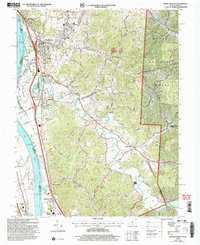
2002 Map of Wheelersburg
USGS Topo · Published 2006About this map
Wheelersburg serves as a primary hub of activity along the Ohio River in this early 21st-century survey, flanked by a network of hills and hollows that define the border between Ohio and Kentucky. The industrial and transit footprint is evident in the path of the Norfolk and Western railroad and landmarks like the Drive-in Theater and Greenup Locks and Dam. Cultural and genealogical history is anchored by several sites of local importance, including Floral Hills Memory Gardens and the Brick Union Ch near the riverfront.
Find a feature on this map
61 named features on this map. Tap any name to fly to it.
Don’t see what you’re looking for? This feature index may not catch every label — zoom into the map to look around manually.
Map Details
Editions of this 2002 Wheelersburg Map
This is the sole edition of this map. No revisions or reprints were ever made.
Other maps of this area

1898 · Ironton
USGS Topo · 1:62,500

1900 · Ironton
USGS Topo · 1:62,500

1911 · Sciotoville
USGS Topo · 1:62,500

1912 · Oak Hill
USGS Topo · 1:62,500

1913 · Sciotoville
USGS Topo · 1:62,500

1926 · Greenup
USGS Topo · 1:48,000

1930 · Greenup
USGS Topo · 1:62,500
1953 · Load
USGS Topo · 1:24,000

1953 · Greenup
USGS Topo · 1:24,000
1953 · Portsmouth
USGS Topo · 1:24,000