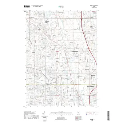
2018 Map of Wheeling
USGS Topo · Published 2018About this map
The Des Plaines River corridor serves as the primary hydrological spine for this portion of Lake and Cook Counties, where suburban development intermingles with significant water management infrastructure. The landscape is defined by a dense network of drainage systems, including the Seavey Drainage Ditch and the Wheeling Drainage Ditch, which support the growth of communities like Buffalo Grove and Wheeling. Small lake bodies such as Big Bear Lake and Lake Potawatomi dot the terrain, while historical nodes like Half Day and Aptakisic mark older points of settlement. The map provides a detailed view of institutional and civic life, showing the campus of Trinity International University and the specialized Worsham College of Mortuary Science. Numerous burial grounds are preserved across the area, including Diamond Lake Cemetery and Willow Lawn Cemetery, offering valuable data for genealogical research in these established Illinois suburbs.
Find a feature on this map
359 named features on this map. Tap any name to fly to it.
Don’t see what you’re looking for? This feature index may not catch every label — zoom into the map to look around manually.
Map Details
Editions of this 2018 Wheeling Map
This is the sole edition of this map. No revisions or reprints were ever made.
Other maps of this area

1900 · Highwood
USGS Topo · 1:62,500

1906 · Waukegan
USGS Topo · 1:62,500

1908 · Waukegan
USGS Topo · 1:62,500

1920 · Grays Lake
USGS Topo · 1:62,500

1923 · Grays Lake
USGS Topo · 1:62,500

1923 · Barrington
USGS Topo · 1:62,500

1927 · Arlington Heights
USGS Topo · 1:24,000

1928 · Wheeling
USGS Topo · 1:24,000

1928 · Highland Park
USGS Topo · 1:24,000

1929 · Park Ridge
USGS Topo · 1:24,000