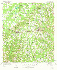
1955 Map of Whigham
USGS Topo · Published 1972About this map
Whigham and Climax serve as the primary hubs on this survey of southwestern Georgia, situated along the Atlantic Coast Line railroad corridor. The landscape is defined by its agrarian and early industrial character, with numerous rural congregations and educational sites such as Salem Ch, Bell-Dixon Sch, and Mt Moriah Sch punctuating the countryside. The presence of Peoples Still and Princes Still points to the region's historical turpentine or distilling activities, while several Strip Mines east of Whigham indicate active mineral extraction during the mid-1950s.
Find a feature on this map
82 named features on this map. Tap any name to fly to it.
Don’t see what you’re looking for? This feature index may not catch every label — zoom into the map to look around manually.
Map Details
Editions of this 1955 Whigham Map
2 editions found
Other maps of this area

1953 · Dothan
USGS Topo · 1:250,000

1954 · Dothan
USGS Topo · 1:250,000

1954 · Tallahassee
USGS Topo · 1:250,000

1955 · Dothan
USGS Topo · 1:250,000

1955 · Bainbridge
USGS Topo · 1:62,500

1955 · Whigham
USGS Topo · 1:62,500

1956 · Havana North
USGS Topo · 1:24,000

1956 · Cairo
USGS Topo · 1:62,500

1956 · Dogtown
USGS Topo · 1:24,000

1956 · Calvary
USGS Topo · 1:24,000