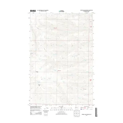
2014 Map of Whiskey Dick Mountain
USGS Topo · Published 2014About this map
Whiskey Dick Mtn dominates the high desert terrain of eastern Kittitas County, where the landscape is defined by a dense network of seasonal drainages and springs. The area around The Pines serves as a central point for water sources like Government Springs and Pine Spring, which have long been vital in this arid environment. The map details the complex drainage systems of Quilomene Cr and Skookumchuck Cr, revealing how water shaped the accessibility of the land. Deep cuts such as Black Rock Canyon and Patte Canyon break up the high plateaus, while primitive routes like Army Rd and Beacon Rd suggest the region's history of military and navigational utility. This survey provides a precise look at the localized nomenclature of the Yakima River watershed's uplands, including several uniquely named features like Wild Horse Spring and Dorse Spring.
Find a feature on this map
42 named features on this map. Tap any name to fly to it.
Don’t see what you’re looking for? This feature index may not catch every label — zoom into the map to look around manually.
Map Details
Editions of this 2014 Whiskey Dick Mountain Map
This is the sole edition of this map. No revisions or reprints were ever made.
Other maps of this area

1920 · Colockum Pass
USGS Topo · 1:125,000

1922 · Colockum Pass
USGS Topo · 1:125,000

1938 · Badger Pocket
USGS Topo · 1:48,000

1939 · Boylston
USGS Topo · 1:48,000

1943 · Boylston
USGS Topo · 1:62,500

1943 · Badger Pocket
USGS Topo · 1:62,500

1950 · Yakima
USGS Topo · 1:250,000

1953 · Ginkgo
USGS Topo · 1:24,000
1953 · East Kittitas
USGS Topo · 1:24,000
1953 · Boylston
USGS Topo · 1:24,000