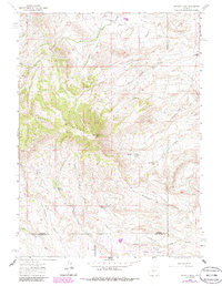
1962 Map of Whiskey Peak
USGS Topo · Published 1985About this map
Whiskey Peak dominates this high-altitude landscape along the border of Fremont, Carbon, and Sweetwater Counties. This 1962 survey, updated with 1980s data, documents a transition from early pioneer settlement to 20th-century energy development. The presence of the Joe Wimmer Homestead (Aband) and Tully Homestead reflects the era of high-country ranching, while the expansion of the Wertz Oil Field and the appearance of a Radio Tower indicate the area's industrial evolution. Navigability in this terrain was defined by a network of Jeep Trails and unnamed Trails that connect family holdings like Diamond Hook Ranch and Stratton Ranch. The drainage patterns of Willow Creek and Big Camp Creek carve deep draws into Green Mountain, supporting the isolated reservoirs and springs essential for local livestock and homesteading operations.
Find a feature on this map
32 named features on this map. Tap any name to fly to it.
Don’t see what you’re looking for? This feature index may not catch every label — zoom into the map to look around manually.
Map Details
Editions of this 1962 Whiskey Peak Map
2 editions found
Other maps of this area

1951 · Bucklin Reservoirs
USGS Topo · 1:24,000

1951 · Split Rock
USGS Topo · 1:24,000

1951 · Split Rock NW
USGS Topo · 1:24,000

1955 · Casper
USGS Topo · 1:250,000

1958 · Casper
USGS Topo · 1:250,000

1961 · Lamont
USGS Topo · 1:24,000

1961 · Hadsell Spring
USGS Topo · 1:24,000

1961 · Bairoil
USGS Topo · 1:24,000

1962 · Casper
USGS Topo · 1:250,000

1962 · Whiskey Peak
USGS Topo · 1:24,000