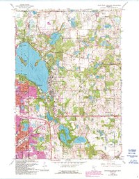
1967 Map of White Bear Lake East
USGS Topo · Published 1993About this map
White Bear Lake dominates the western portion of this 1967 survey, its eastern shores lined with established communities like Dellwood, Mahtomedi, and Birchwood. The landscape is a complex network of glacial kettle lakes and wetlands, ranging from the large Lake De Montreville to smaller named bodies like Echo Lake and Mann Lake. Post-war suburban growth is evident in the residential expansion of Maplewood and North ST Paul, while rural remnants such as Benson Airport and several Gravel Pits persist on the outskirts.
Find a feature on this map
60 named features on this map. Tap any name to fly to it.
Don’t see what you’re looking for? This feature index may not catch every label — zoom into the map to look around manually.
Map Details
Editions of this 1967 White Bear Lake East Map
5 editions found

Other maps of this area

1896 · St. Paul
USGS Topo · 1:62,500

1902 · White Bear
USGS Topo · 1:62,500

1946 · Hudson
USGS Topo · 1:62,500

1948 · Stillwater
USGS Topo · 1:62,500

1949 · Hudson
USGS Topo · 1:62,500

1949 · Stillwater
USGS Topo · 1:62,500

1949 · Lake Elmo
USGS Topo · 1:24,000

1949 · Hudson
USGS Topo · 1:24,000

1950 · Lake Elmo
USGS Topo · 1:24,000

1950 · Hudson
USGS Topo · 1:24,000