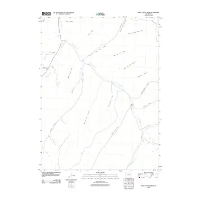
2010 Map of White Coyote Draw
USGS Topo · Published 2010About this map
West Douglas Creek and East Douglas Creek carve through this high-desert landscape in Rio Blanco County, defining a complex drainage system within the Piceance Basin. The 2010 survey highlights a remote ranching and resource territory where human presence is sparse, centered primarily on the Brandy Ranch along the eastern creek bed. A network of county roads, including County Rd 27 and County Rd 120, follows the natural contours of the canyons and draws, providing the only access to this isolated terrain. The map captures the intricate geography of names like White Coyote Draw and Pollock Canyon, illustrating how the land is segmented by deep channels such as West Dry Lake Canyon and East Dry Lake Canyon. This document is a clear record of the region's topographical character before modern industrial or environmental shifts might alter these namesake watercourses.
Find a feature on this map
27 named features on this map. Tap any name to fly to it.
Don’t see what you’re looking for? This feature index may not catch every label — zoom into the map to look around manually.
Map Details
Editions of this 2010 White Coyote Draw Map
This is the sole edition of this map. No revisions or reprints were ever made.
Other maps of this area

1956 · Grand Junction
USGS Topo · 1:250,000

1959 · Grand Junction
USGS Topo · 1:250,000

1960 · Grand Junction
USGS Topo · 1:250,000

1962 · Grand Junction
USGS Topo · 1:250,000

1964 · Grand Junction
USGS Topo · 1:250,000

1964 · Brushy Point
USGS Topo · 1:24,000
1964 · Philadelphia Creek
USGS Topo · 1:24,000
1964 · Water Canyon
USGS Topo · 1:24,000

1964 · Black Cabin Gulch
USGS Topo · 1:24,000
1964 · White Coyote Draw
USGS Topo · 1:24,000