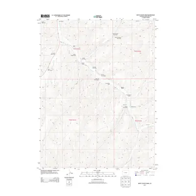
2013 Map of White Coyote Draw
USGS Topo · Published 2013About this map
Brandy Ranch sits within a complex network of canyons and draws in the western Colorado plateau. This high-desert drainage system is defined by the convergence of several major watercourses, including East Douglas Creek and West Douglas Creek. The landscape is etched with distinctive local landmarks such as White Coyote Draw, Pollock Canyon, and Calf Canyon, illustrating a traditional ranching territory defined more by its terrain and hydrology than by urban development. Modern county roads, such as CO Road 27 and CO Road 138, follow the natural contours of the land, connecting the various draws. The inclusion of features like Tommys Draw and New Mexico Draw highlights the unique toponymy of this part of Rio Blanco County, where every fold in the earth carries a specific name.
Find a feature on this map
32 named features on this map. Tap any name to fly to it.
Don’t see what you’re looking for? This feature index may not catch every label — zoom into the map to look around manually.
Map Details
Editions of this 2013 White Coyote Draw Map
This is the sole edition of this map. No revisions or reprints were ever made.
Other maps of this area

1956 · Grand Junction
USGS Topo · 1:250,000

1959 · Grand Junction
USGS Topo · 1:250,000

1960 · Grand Junction
USGS Topo · 1:250,000

1962 · Grand Junction
USGS Topo · 1:250,000

1964 · Grand Junction
USGS Topo · 1:250,000

1964 · Brushy Point
USGS Topo · 1:24,000
1964 · Philadelphia Creek
USGS Topo · 1:24,000
1964 · Water Canyon
USGS Topo · 1:24,000

1964 · Black Cabin Gulch
USGS Topo · 1:24,000
1964 · White Coyote Draw
USGS Topo · 1:24,000