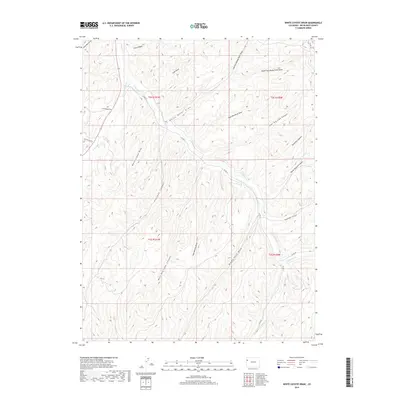
2019 Map of White Coyote Draw
USGS Topo · Published 2019About this map
Douglas Cr and its primary tributaries, E Douglas Cr and W Douglas Cr, carve a complex drainage system through this high-desert landscape in Rio Blanco County. The area is defined by deep incisions and named landforms like White Coyote Draw and Pollock Canyon, illustrating a terrain shaped by persistent erosion. These features, along with Calf Canyon and Horse Pasture Canyon, suggest a history of seasonal grazing and land use. Local transport is represented by routes such as Co RD 27 and Co RD 128, which follow the natural contours of the draws. The inclusion of Coal Draw hints at the region's geological potential, while the confluence near Cathedral Cr anchors the southern portion of the survey.
Find a feature on this map
29 named features on this map. Tap any name to fly to it.
Don’t see what you’re looking for? This feature index may not catch every label — zoom into the map to look around manually.
Map Details
Editions of this 2019 White Coyote Draw Map
This is the sole edition of this map. No revisions or reprints were ever made.
Other maps of this area

1956 · Grand Junction
USGS Topo · 1:250,000

1959 · Grand Junction
USGS Topo · 1:250,000

1960 · Grand Junction
USGS Topo · 1:250,000

1962 · Grand Junction
USGS Topo · 1:250,000

1964 · Grand Junction
USGS Topo · 1:250,000

1964 · Brushy Point
USGS Topo · 1:24,000
1964 · Philadelphia Creek
USGS Topo · 1:24,000
1964 · Water Canyon
USGS Topo · 1:24,000

1964 · Black Cabin Gulch
USGS Topo · 1:24,000
1964 · White Coyote Draw
USGS Topo · 1:24,000