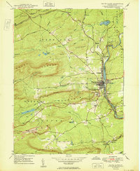
1950 Map of White Haven
USGS Topo · Published 1950About this map
The Lehigh River carves a deep valley through this corner of the Anthracite region, serving as the primary corridor for the Central RR of Pennsylvania and the Lehigh Valley railroads. The town of White Haven stands as the central hub of this 1950 landscape, surrounded by smaller settlements like Tannery and Bridgeport. The map records a period of heavy industrial activity on Green Mountain, where extensive Strip Mine operations are visible alongside infrastructure like Scale Siding.
Find a feature on this map
53 named features on this map. Tap any name to fly to it.
Don’t see what you’re looking for? This feature index may not catch every label — zoom into the map to look around manually.
Map Details
Editions of this 1950 White Haven Map
2 editions found
Other maps of this area

1889 · Hazleton
USGS Topo · 1:62,500

1891 · Wilkesbarre
USGS Topo · 1:62,500

1891 · Hazleton
USGS Topo · 1:62,500

1893 · Hazleton
USGS Topo · 1:62,500

1894 · Wilkesbarre
USGS Topo · 1:62,500

1922 · Mauch Chunk
USGS Topo · 1:62,500

1922 · Stoddartsville
USGS Topo · 1:62,500

1924 · Stoddartsville
USGS Topo · 1:62,500

1924 · Mauch Chunk
USGS Topo · 1:62,500

1943 · Scranton
USGS Topo · 1:125,000