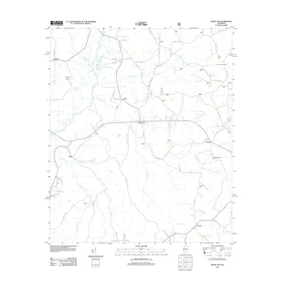
2012 Map of White Oak
USGS Topo · Published 2012About this map
The Strong River and White Oak Cr define this rural landscape on the border of Smith and Rankin counties. Small communities like White Oak, Gunn, and Traxler are linked by a network of local roads including Smith Line Rd and Overby Rd. The map reveals a land structured by family heritage and resource extraction, notably the Puckett Oil and Gas Field in the northwest. Genealogists will find a wealth of local burial sites, such as Old Field Cem, Miley Cem, and Everett Cem, which mark the presence of established families near the winding courses of Jump Cr and Rocky Cr. The elevated terrain of Heater Ridge and the standing Coursey Lookout Tower near Heater provide landmarks in a region largely defined by its timber and agricultural heritage.
Find a feature on this map
78 named features on this map. Tap any name to fly to it.
Don’t see what you’re looking for? This feature index may not catch every label — zoom into the map to look around manually.
Map Details
Editions of this 2012 White Oak Map
This is the sole edition of this map. No revisions or reprints were ever made.
Other maps of this area

1935 · White Oak
USGS Topo · 1:24,000

1953 · Hattiesburg
USGS Topo · 1:250,000

1953 · Meridian
USGS Topo · 1:250,000

1957 · Meridian
USGS Topo · 1:250,000

1958 · Hattiesburg
USGS Topo · 1:250,000

1965 · Meridian
USGS Topo · 1:250,000
1968 · Homewood
USGS Topo · 1:24,000

1968 · White Oak
USGS Topo · 1:24,000
1968 · Puckett
USGS Topo · 1:24,000
1968 · Polkville
USGS Topo · 1:24,000