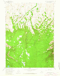
1958 Map of White Rock Canyon
USGS Topo · Published 1964About this map
Medicine Bow National Forest dominates the southern landscape of this 1958 survey, where the headwaters of the Medicine Bow River begin their descent through high-altitude parks and canyons. The map records the functional infrastructure of mid-century Wyoming ranching and timber operations, specifically noting the Wick Brothers Ranch and their specialized Wick Brothers Sheep Camp to the south.
Find a feature on this map
31 named features on this map. Tap any name to fly to it.
Don’t see what you’re looking for? This feature index may not catch every label — zoom into the map to look around manually.
Map Details
Editions of this 1958 White Rock Canyon Map
4 editions found
Other maps of this area

1906 · Medicine Bow
USGS Topo · 1:125,000

1908 · Medicine Bow
USGS Topo · 1:125,000

1954 · Rawlins
USGS Topo · 1:250,000

1955 · Elk Mountain
USGS Topo · 1:24,000

1955 · Elk Mountain SW
USGS Topo · 1:24,000

1958 · Rawlins
USGS Topo · 1:250,000

1958 · White Rock Canyon
USGS Topo · 1:24,000

1958 · Arlington
USGS Topo · 1:24,000

1958 · Mc Fadden
USGS Topo · 1:24,000

1958 · T L Ranch
USGS Topo · 1:24,000