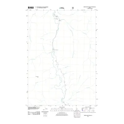
2011 Map of White Rock Peak
USGS Topo · Published 2011About this map
The South Fork Salmon River carves a deep path through the center of this terrain, serving as the primary corridor for movement and recreation in Valley County. Near the northern reach, the Lodgepole Roadside Park and adjacent Lodgepole Campground mark the intersection of water and roadway along 674. The landscape is defined by its dramatic hydrology, with numerous tributaries such as Snowslide Creek, Blackmare Creek, and Goat Creek feeding into the main river fork.
Find a feature on this map
25 named features on this map. Tap any name to fly to it.
Don’t see what you’re looking for? This feature index may not catch every label — zoom into the map to look around manually.
Map Details
Editions of this 2011 White Rock Peak Map
This is the sole edition of this map. No revisions or reprints were ever made.
Other maps of this area

1954 · Gold Fork
USGS Topo · 1:62,500

1954 · Warm Lake
USGS Topo · 1:62,500

1957 · Challis
USGS Topo · 1:250,000

1960 · Challis
USGS Topo · 1:250,000

1963 · Challis
USGS Topo · 1:250,000

1973 · Blackmare
USGS Topo · 1:24,000

1973 · White Rock Peak
USGS Topo · 1:24,000
1973 · Log Mountain
USGS Topo · 1:24,000

1973 · Fitsum Peak
USGS Topo · 1:24,000
1973 · Caton Lake
USGS Topo · 1:24,000