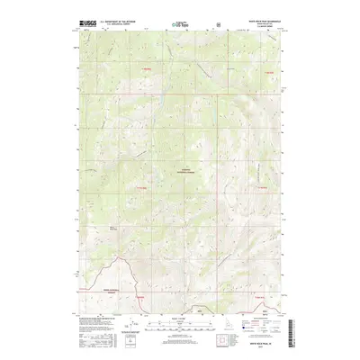
2017 Map of White Rock Peak
USGS Topo · Published 2017About this map
White Rock Peak serves as a prominent landmark in this high-altitude section of the Idaho backcountry, where the South Fork Salmon River carves a deep path between the Payette National Forest and the Boise National Forest. The landscape is defined by its dramatic elevation changes, with Martin Ridge and Indian Ridge providing natural boundaries for the various drainages that feed the river system. Notable among these is the Four Mile / Goat Creek (SFSR) and the Blackmare Creek systems. Human infrastructure is limited to the winding Nat For Dev Rd 474, which traverses the ridge lines above Holdover Cr and Sister Cr. This survey illustrates the protected wilderness character of Valley County as it stood in the late 2010s, focusing on the complex topography around peaks like Log Mountain.
Find a feature on this map
32 named features on this map. Tap any name to fly to it.
Don’t see what you’re looking for? This feature index may not catch every label — zoom into the map to look around manually.
Map Details
Editions of this 2017 White Rock Peak Map
This is the sole edition of this map. No revisions or reprints were ever made.
Other maps of this area

1954 · Gold Fork
USGS Topo · 1:62,500

1954 · Warm Lake
USGS Topo · 1:62,500

1957 · Challis
USGS Topo · 1:250,000

1960 · Challis
USGS Topo · 1:250,000

1963 · Challis
USGS Topo · 1:250,000

1973 · Blackmare
USGS Topo · 1:24,000

1973 · White Rock Peak
USGS Topo · 1:24,000
1973 · Log Mountain
USGS Topo · 1:24,000

1973 · Fitsum Peak
USGS Topo · 1:24,000
1973 · Caton Lake
USGS Topo · 1:24,000