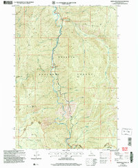
2004 Map of White Rock Peak
USGS Topo · Published 2007About this map
The South Fork Salmon River carves a deep central corridor through this landscape, serving as the primary geographical axis for the surrounding mountain reaches. Along its banks, the settlement of Poverty Flat and the Four Mile CG represent the limited human footprint in this high-elevation backcountry. The terrain is defined by prominent summits such as White Rock Peak and Blackmare Peak, which are accessible via a network of historic forest paths including the Cougar Creek Trail and Log Mnt Trail. Geothermal activity is noted at the Spring (Hot) near the river junction. The map also delineates the boundary between the Payette National Forest and the Boise National Forest at the Banger Ranger District, illustrating the administrative and ecological divisions of central Idaho's wilderness just after the millennium.
Find a feature on this map
33 named features on this map. Tap any name to fly to it.
Don’t see what you’re looking for? This feature index may not catch every label — zoom into the map to look around manually.
Map Details
Editions of this 2004 White Rock Peak Map
This is the sole edition of this map. No revisions or reprints were ever made.
Other maps of this area

1954 · Gold Fork
USGS Topo · 1:62,500

1954 · Warm Lake
USGS Topo · 1:62,500

1957 · Challis
USGS Topo · 1:250,000

1960 · Challis
USGS Topo · 1:250,000

1963 · Challis
USGS Topo · 1:250,000

1973 · Blackmare
USGS Topo · 1:24,000

1973 · White Rock Peak
USGS Topo · 1:24,000
1973 · Log Mountain
USGS Topo · 1:24,000

1973 · Fitsum Peak
USGS Topo · 1:24,000
1973 · Caton Lake
USGS Topo · 1:24,000