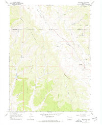
1966 Map of White Rock
USGS Topo · Published 1970About this map
Gray Hills and Dick Ridge define the complex, eroded landscape of the Piceance Basin in northwestern Colorado. This mid-1960s environment is characterized by a sparse, resource-driven footprint where early industrial features like a Claypit and Storage Bins appear alongside numerous water sources critical for livestock and exploration. The drainage network is particularly dense, featuring Coyote Deep Channel Creek and the meandering path of East Fork Strawberry Creek.
Find a feature on this map
30 named features on this map. Tap any name to fly to it.
Don’t see what you’re looking for? This feature index may not catch every label — zoom into the map to look around manually.
Map Details
Editions of this 1966 White Rock Map
2 editions found
Other maps of this area

1907 · White River
USGS Topo · 1:125,000

1910 · Danforth Hills
USGS Topo · 1:125,000

1910 · White River
USGS Topo · 1:125,000

1912 · Meeker
USGS Topo · 1:62,500

1912 · Axial
USGS Topo · 1:62,500

1914 · Meeker
USGS Topo · 1:62,500

1914 · Axial
USGS Topo · 1:62,500

1954 · Vernal
USGS Topo · 1:250,000

1954 · Craig
USGS Topo · 1:250,000

1957 · Craig
USGS Topo · 1:250,000