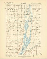
1918 Map of White Rock
USGS Topo · Published 1918About this map
Lake Traverse and the Bois de Sioux River form the focal point of this 1915 survey, marking the intersection of South Dakota, Minnesota, and North Dakota. This tri-state landscape is defined by the Sisseton and Wahpeton Indian Reservation in the west and a dense network of early rural schoolhouses that served the agricultural community. Settlements like White Rock and Rosholt are positioned along competing rail lines, including the Chicago Milwaukee and St Paul and the Minneapolis Sault Ste Marie and St Paul. The map provides a detailed look at the water-management of the era, showing the Big Slough and the Mustinka River feeding into the lake valley. For genealogists, the inclusion of named school sites such as Teure School, Knutson School, and Norburg School offers a precise look at the educational infrastructure of Roberts and Traverse counties before the mid-century consolidation of rural districts.
Find a feature on this map
50 named features on this map. Tap any name to fly to it.
Don’t see what you’re looking for? This feature index may not catch every label — zoom into the map to look around manually.
Map Details
Editions of this 1918 White Rock Map
4 editions found
Other maps of this area

1904 · Wahpeton
USGS Topo · 1:125,000

1915 · White Rock
USGS Topo · 1:62,500

1916 · Peever
USGS Topo · 1:62,500

1916 · Beardsley
USGS Topo · 1:62,500

1917 · New Effington
USGS Topo · 1:62,500

1918 · Peever
USGS Topo · 1:62,500

1918 · White Rock
USGS Topo · 1:62,500

1918 · Beardsley
USGS Topo · 1:62,500

1950 · Graceville
USGS Topo · 1:62,500

1951 · Wheaton
USGS Topo · 1:62,500