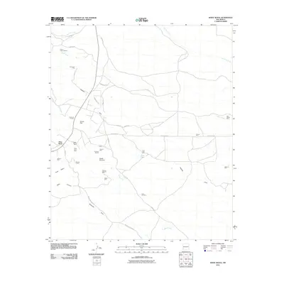
2010 Map of White Signal
USGS Topo · Published 2010About this map
Mining operations and ranching claims define the arid landscape around White Signal in this early 21st-century survey. The map reveals an intensive history of mineral extraction throughout the high-desert terrain, notably at the Gold Lake Mine and the Chapman Turquoise Mine. A network of unpaved roads and tracks, including Barka Rd and Johney Macdonald Rd, provides access to numerous named prospects and shafts. Distinctive geological features such as Saddle Mountain and the Hogback ridge dictate the drainage patterns of Walnut Creek and Cherry Creek. The presence of the 7 XV Ranch and its associated 7 XV Ranch Deposits suggests a mixed-use environment where cattle ranching and geological exploration coexist. To the west, the Three Sisters landform and Keese Canyon offer notable landmarks for those tracing the topographic character of this part of Grant County.
Find a feature on this map
42 named features on this map. Tap any name to fly to it.
Don’t see what you’re looking for? This feature index may not catch every label — zoom into the map to look around manually.
Map Details
Editions of this 2010 White Signal Map
This is the sole edition of this map. No revisions or reprints were ever made.
Other maps of this area

1909 · Silver City
USGS Topo · 1:125,000

1949 · Whitewater
USGS Topo · 1:24,000

1949 · Hurley West
USGS Topo · 1:24,000

1950 · Tyrone
USGS Topo · 1:24,000

1950 · White Signal
USGS Topo · 1:24,000

1950 · Wind Mountain
USGS Topo · 1:24,000

1950 · Burro Peak
USGS Topo · 1:24,000

1951 · White Signal
USGS Topo · 1:24,000

1951 · Big Burro Mountains
USGS Topo · 1:24,000
1951 · Tyrone
USGS Topo · 1:24,000