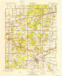
1951 Map of Whitehouse
USGS Topo · Published 1952About this map
The Whitehouse and Monclova areas of Lucas County are defined by a complex network of agricultural drainage and the sandy terrain of the Oak Openings region during the early 1950s. The Wabash Railroad serves as a primary transit corridor, cutting diagonally through the landscape and connecting smaller settlements like Garden and Crissey. This era shows a rural landscape transitioning toward modern infrastructure, evidenced by the presence of the Airway Beacon and Swanton Water Works. The landscape is heavily engineered for farming, with dozens of named drainage features such as Webster Ditch, Bovee Ditch, and Strong Ditch channeling water toward the Swan Creek and the Ottawa River. Local history is preserved in landmarks like Roberts Chapel and the Whitehouse Cem, while the Valley Wood Golf Club and Metropolitan Park indicate the early development of recreational spaces near the urbanizing fringes of the county.
Find a feature on this map
97 named features on this map. Tap any name to fly to it.
Don’t see what you’re looking for? This feature index may not catch every label — zoom into the map to look around manually.
Map Details
Editions of this 1951 Whitehouse Map
This is the sole edition of this map. No revisions or reprints were ever made.
Other maps of this area

1900 · Toledo
USGS Topo · 1:62,500

1901 · Bowling Green
USGS Topo · 1:62,500

1903 · Bowling Green
USGS Topo · 1:62,500

1909 · Mc Clure
USGS Topo · 1:62,500

1911 · Swanton
USGS Topo · 1:62,500

1914 · Swanton
USGS Topo · 1:62,500

1935 · Grand Rapids
USGS Topo · 1:24,000

1935 · Whitehouse
USGS Topo · 1:24,000

1935 · Maumee
USGS Topo · 1:24,000

1935 · Berkey
USGS Topo · 1:24,000