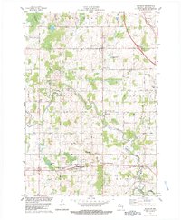
1978 Map of Whitelaw
USGS Topo · Published 1979About this map
Kellnersville and Whitelaw serve as the primary hubs in this late-1970s landscape, which is defined by a dense network of dairy-land section roads and small agricultural communities. The southern portion of the map is dominated by the corridor of the Chicago and North Western railroad, which passes through Whitelaw and near the Maple Crest Sanitarium. Local heritage is well-preserved through several rural burial grounds and religious sites, including St Augustine Ch and Cato Heights Cem. The terrain is shaped by the winding courses of the Branch River and Manitowoc River, which cut through the townships of Franklin, Kossuth, and Cato. Small water bodies like Kellners Lake and Hempton Lake provide localized drainage points amidst the rolling farm fields and scattered woodlots typical of eastern Wisconsin.
Find a feature on this map
42 named features on this map. Tap any name to fly to it.
Don’t see what you’re looking for? This feature index may not catch every label — zoom into the map to look around manually.
Map Details
Editions of this 1978 Whitelaw Map
2 editions found
Other maps of this area

1954 · Kewaunee
USGS Topo · 1:62,500

1954 · Manitowoc
USGS Topo · 1:62,500

1954 · Denmark
USGS Topo · 1:62,500

1954 · Reedsville
USGS Topo · 1:62,500

1954 · Manitowoc
USGS Topo · 1:24,000

1954 · Manitowoc
USGS Topo · 1:250,000

1958 · Manitowoc
USGS Topo · 1:250,000
1978 · Clarks Mills
USGS Topo · 1:24,000

1978 · Denmark
USGS Topo · 1:24,000
1978 · Reedsville
USGS Topo · 1:24,000