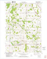
1978 Map of Whitelaw
USGS Topo · Published 1979About this map
The Chicago and North Western corridor defines the southern half of this Manitowoc County landscape, connecting the village of Whitelaw to the hamlet of Branch. This late 1970s survey reveals a rural society structured around crossroads and watercourses, from the Coopertown Swamp in the north to the Manitowoc River in the southeast. Numerous small settlements like Polifka Corners and Reifs Mills persist along a dense grid of farm-to-market roads, such as Reifs Mills Road and Palm Grove Road.
Find a feature on this map
68 named features on this map. Tap any name to fly to it.
Don’t see what you’re looking for? This feature index may not catch every label — zoom into the map to look around manually.
Map Details
Editions of this 1978 Whitelaw Map
2 editions found
Other maps of this area

1954 · Kewaunee
USGS Topo · 1:62,500

1954 · Manitowoc
USGS Topo · 1:62,500

1954 · Denmark
USGS Topo · 1:62,500

1954 · Reedsville
USGS Topo · 1:62,500

1954 · Manitowoc
USGS Topo · 1:24,000

1954 · Manitowoc
USGS Topo · 1:250,000

1958 · Manitowoc
USGS Topo · 1:250,000
1978 · Clarks Mills
USGS Topo · 1:24,000

1978 · Denmark
USGS Topo · 1:24,000
1978 · Reedsville
USGS Topo · 1:24,000