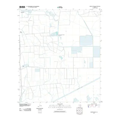
2010 Map of Whites Ranch
USGS Topo · Published 2010About this map
Coastal water management and irrigation infrastructure define this landscape in Chambers County, where the Intracoastal Waterway cuts across the southern marshlands. The area is anchored by the Whites Ranch and Sea Breeze settlements, with much of the northern terrain dominated by organized water control systems like the Devers East Canal and Spindletop Bayou. The presence of the Spindletop Weir Saltwater Barrier Dam and Marshall Estate Dam Number 2 highlights the critical role of salinity control and reservoir management for the surrounding agricultural and ranching operations. Navigational and drainage features including the North Prong Mud Bayou and Mud Bayou weave through the low-lying coastal plains, while a network of named local routes like White Ranch Rd and Matthews Ranch Rd provide access to the remote marsh interiors and the Marshall Estate Lake Number 2.
Find a feature on this map
19 named features on this map. Tap any name to fly to it.
Don’t see what you’re looking for? This feature index may not catch every label — zoom into the map to look around manually.
Map Details
Editions of this 2010 Whites Ranch Map
This is the sole edition of this map. No revisions or reprints were ever made.
Other maps of this area

1931 · High Island
USGS Topo · 1:24,000

1943 · High Island
USGS Topo · 1:31,680

1943 · Sea Breeze
USGS Topo · 1:24,000

1943 · Stowell
USGS Topo · 1:24,000

1945 · Sea Breeze
USGS Topo · 1:31,680

1950 · Houston
USGS Topo · 1:250,000

1956 · Houston
USGS Topo · 1:250,000

1961 · Star Lake
USGS Topo · 1:24,000

1961 · Mud Lake
USGS Topo · 1:24,000
1962 · High Island
USGS Topo · 1:24,000