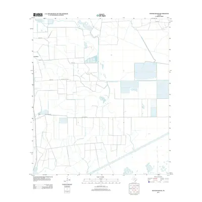
2013 Map of Whites Ranch
USGS Topo · Published 2013About this map
Sea Breeze and the namesake Whites Ranch anchor this coastal Texas landscape, which is defined by an intricate network of drainage and irrigation infrastructure. The geography is dominated by water management features such as the Devers East Canal and the Spindletop Ditch, reflecting the region's agricultural and industrial engineering. These artificial waterways intersect with natural drainages like Spindletop Bayou and Elm Bayou, creating a grid-like pattern across the low-lying terrain. To the north, Marshall Estate Lake Number 2 and the Catfish Acres Reservoir further illustrate the importance of water storage in Chambers County. Local road networks, including Matthews Ranch Rd and Hebert Rd, follow these canal lines, providing a clear view of how land use and transportation have been shaped by the coastal hydrology.
Find a feature on this map
20 named features on this map. Tap any name to fly to it.
Don’t see what you’re looking for? This feature index may not catch every label — zoom into the map to look around manually.
Map Details
Editions of this 2013 Whites Ranch Map
This is the sole edition of this map. No revisions or reprints were ever made.
Other maps of this area

1931 · High Island
USGS Topo · 1:24,000

1943 · High Island
USGS Topo · 1:31,680

1943 · Sea Breeze
USGS Topo · 1:24,000

1943 · Stowell
USGS Topo · 1:24,000

1945 · Sea Breeze
USGS Topo · 1:31,680

1950 · Houston
USGS Topo · 1:250,000

1956 · Houston
USGS Topo · 1:250,000

1961 · Star Lake
USGS Topo · 1:24,000

1961 · Mud Lake
USGS Topo · 1:24,000
1962 · High Island
USGS Topo · 1:24,000