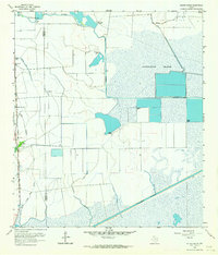
1962 Map of Whites Ranch
USGS Topo · Published 1964About this map
Whites Ranch and Sea Breeze anchor the western edge of this coastal prairie landscape, where the Gulf Colorado and Santa Fe railroad runs parallel to the Gulf Colorado and Santa Fe line. This early 1960s survey documents a highly engineered hydrologic system designed for both industry and irrigation, characterized by the extensive Devers East Canal, Spindletop Ditch, and the massive Stanolind Reservoir.
Find a feature on this map
22 named features on this map. Tap any name to fly to it.
Don’t see what you’re looking for? This feature index may not catch every label — zoom into the map to look around manually.
Map Details
Editions of this 1962 Whites Ranch Map
2 editions found
Other maps of this area

1931 · High Island
USGS Topo · 1:24,000

1943 · High Island
USGS Topo · 1:31,680

1943 · Sea Breeze
USGS Topo · 1:24,000

1943 · Stowell
USGS Topo · 1:24,000

1945 · Sea Breeze
USGS Topo · 1:31,680

1950 · Houston
USGS Topo · 1:250,000

1956 · Houston
USGS Topo · 1:250,000

1961 · Star Lake
USGS Topo · 1:24,000

1961 · Mud Lake
USGS Topo · 1:24,000
1962 · High Island
USGS Topo · 1:24,000