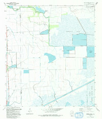
1993 Map of Whites Ranch
USGS Topo · Published 1994About this map
Whites Ranch and the coastal settlement of Sea Breeze anchor this landscape of salt marsh and industrial infrastructure along the Gulf Coast. The terrain is defined by an intricate network of drainage and transport, including the Intracoastal Waterway and the Devers East Canal. Significant energy production is evident in the northeast, where the Big Hill Oil Field and the Strategic Petroleum Reserve represent vital economic components of the region. Extensive water management is visible through numerous Pumping Stations, Tide Gates, and water bodies like Stanolind Reservoir and Spindletop Reservoir. Conservation efforts are also prominent, with a portion of the Mc Faddin National Wildlife Refuge protecting the sensitive wetlands of Spindletop Marsh. The boundary between Chambers and Jefferson Counties runs through this low-lying area, where bayous like Elm Bayou and Mud Bayou meander through the prairie.
Find a feature on this map
20 named features on this map. Tap any name to fly to it.
Don’t see what you’re looking for? This feature index may not catch every label — zoom into the map to look around manually.
Map Details
Editions of this 1993 Whites Ranch Map
This is the sole edition of this map. No revisions or reprints were ever made.
Other maps of this area

1931 · High Island
USGS Topo · 1:24,000

1943 · High Island
USGS Topo · 1:31,680

1943 · Sea Breeze
USGS Topo · 1:24,000

1943 · Stowell
USGS Topo · 1:24,000

1945 · Sea Breeze
USGS Topo · 1:31,680

1950 · Houston
USGS Topo · 1:250,000

1956 · Houston
USGS Topo · 1:250,000

1961 · Star Lake
USGS Topo · 1:24,000

1961 · Mud Lake
USGS Topo · 1:24,000
1962 · High Island
USGS Topo · 1:24,000