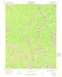
1968 Map of Whitesville
USGS Topo · Published 1977About this map
Whitesville serves as the focal point for this industrial landscape where the Big Coal River and Marsh Fork meet. The 1968 topography reveal a region defined by extraction, with numerous Strip Mine operations and tipples clustered along the Chesapeake and Ohio railroad corridors. Small coal camp communities like Lindytown, Montcoal, and Blue Pennant are deeply integrated into the winding valley floors, often centered around their proximity to the rail lines and local schools such as Marsh Fork High Sch. Local family history is preserved in several small burial grounds, including Jarrells Cem and Mordue Cem, situated on the steep slopes of Cherry Pond Mountain and Kayford Mountain. This map documents the extent of land usage during a peak period of West Virginia coal production before later environmental transitions altered these narrow hollows.
Find a feature on this map
58 named features on this map. Tap any name to fly to it.
Don’t see what you’re looking for? This feature index may not catch every label — zoom into the map to look around manually.
Map Details
Editions of this 1968 Whitesville Map
3 editions found
Other maps of this area

1891 · Oceana
USGS Topo · 1:125,000

1891 · Raleigh
USGS Topo · 1:125,000

1893 · Oceana
USGS Topo · 1:125,000

1897 · Kanawha Falls
USGS Topo · 1:125,000

1897 · Raleigh
USGS Topo · 1:125,000

1898 · Oceana
USGS Topo · 1:125,000

1899 · Charleston
USGS Topo · 1:125,000

1900 · Kanawha Falls
USGS Topo · 1:125,000

1901 · Kanawha Falls
USGS Topo · 1:125,000

1902 · Raleigh
USGS Topo · 1:125,000