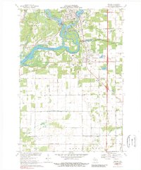
1970 Map of Whiting
USGS Topo · Published 1989About this map
The Wisconsin River corridor dominates this Portage County landscape, defining the industrial and social character of Whiting and Plover in the early 1970s. Industrial infrastructure, including a Powerplant, Sewage Disposal facility, and several Gravel Pits, sits alongside the river's edge, while residential growth pushes eastward toward the Little Plover River. The map captures a unique concentration of community landmarks, from the River Pines Sanatorium and St Bronislava church to more ephemeral features like a Drive-in Theater and multiple trailer parks. South of the main settlements, the land transitions into a strictly grid-based agricultural pattern throughout the townships of Grant and Buena Vista, where irrigation and drainage projects are marked by Ditch No 1 and Ditch No 2. This survey preserves the exact rail-side layout of the Green Bay and Western railroad as it serviced the paper-milling region.
Find a feature on this map
48 named features on this map. Tap any name to fly to it.
Don’t see what you’re looking for? This feature index may not catch every label — zoom into the map to look around manually.
Map Details
Editions of this 1970 Whiting Map
2 editions found
Other maps of this area

1955 · Rosholt
USGS Topo · 1:48,000

1955 · Green Bay
USGS Topo · 1:250,000

1956 · Stevens Point
USGS Topo · 1:48,000

1957 · Amherst
USGS Topo · 1:48,000

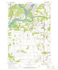
1957 · Whiting
USGS Topo · 1:48,000

1969 · Arnott
USGS Topo · 1:24,000
1969 · Almond
USGS Topo · 1:24,000
1969 · Polonia
USGS Topo · 1:24,000

1970 · Kellner
USGS Topo · 1:24,000

1970 · Stevens Point
USGS Topo · 1:24,000