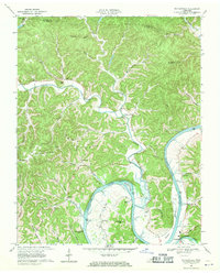
1968 Map of Whitleyville
USGS Topo · Published 1970About this map
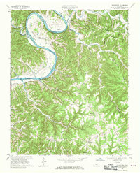
Whitleyville lies at the heart of this landscape, situated along the winding course of Jennings Creek just before it joins the Cumberland River. The topography is defined by the sharp, interlocking ridges and hollows characteristic of the Highland Rim, featuring family-named landmarks like Vanhooser Hol and Aunt Sal Hol. Historical interest centers on the area's spiritual and civic life, evidenced by the Willow Grove Ch and South Fork Ch, alongside numerous small family burial grounds such as the Draper-Naff Cem and Clark Cem. The river's path is marked by distinctive geological features, including Simpson Island and the prominent Chimney Knob. This late-1960s perspective captures the region before the completion of the Cordell Hull Dam downstream significantly altered the river's character, showing the original river miles and landings like Blue Ash Cut Hill.
Find a feature on this map
69 named features on this map. Tap any name to fly to it.
Don’t see what you’re looking for? This feature index may not catch every label — zoom into the map to look around manually.
Map Details
Editions of this 1968 Whitleyville Map
2 editions found
Other maps of this area

1925 · Gainesboro
USGS Topo · 1:62,500

1929 · Gainesboro
USGS Topo · 1:62,500

1929 · Tompkinsville
USGS Topo · 1:62,500

1931 · Red Boiling Springs
USGS Topo · 1:62,500

1932 · Carthage
USGS Topo · 1:62,500

1956 · Corbin
USGS Topo · 1:250,000

1958 · Corbin
USGS Topo · 1:250,000
1968 · Dodson Branch
USGS Topo · 1:24,000
1968 · Willette
USGS Topo · 1:24,000
1968 · Burristown
USGS Topo · 1:24,000