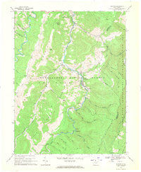
1968 Map of Whitmer
USGS Topo · Published 1971About this map
Whitmer and the nearby timber settlement of Horton anchor this topographic survey of the upper Dry Fork valley in the late 1960s. The landscape is defined by the high, parallel ridges of Middle Mountain and Dry Fork Mountain, where human presence is marked by isolated mountain communities like Gandy and uniquely named localities such as Little Low Place and Little Italy. The map captures the area's transition into a recreational hub within the Monongahela National Forest, including the Seneca Rocks National Recreation Area and developments like the Swallow Rock Campground. Rural life is evidenced by Bethel Ch and several small family cemeteries scattered along the river bottoms and hollows. The presence of a Radio Tower on Haines Knob and various cross-mountain pipelines reflect the infrastructure supporting the region during this era.
Find a feature on this map
53 named features on this map. Tap any name to fly to it.
Don’t see what you’re looking for? This feature index may not catch every label — zoom into the map to look around manually.
Map Details
Editions of this 1968 Whitmer Map
This is the sole edition of this map. No revisions or reprints were ever made.
Other maps of this area

1889 · Beverly
USGS Topo · 1:125,000

1892 · Beverly
USGS Topo · 1:125,000

1892 · Franklin
USGS Topo · 1:125,000

1896 · Franklin
USGS Topo · 1:125,000

1920 · Onego
USGS Topo · 1:62,500

1921 · Onego
USGS Topo · 1:48,000

1922 · Onego
USGS Topo · 1:62,500

1922 · Horton
USGS Topo · 1:48,000

1922 · Spruce Knob
USGS Topo · 1:48,000

1922 · Circleville
USGS Topo · 1:62,500