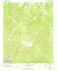
1970 Map of Whitmire North
USGS Topo · Published 1973About this map
The Sumter National Forest defines the wooded landscape of this Union County region, where the Tyger River and Enoree River converge near the town of Whitmire. This 1970s record shows a rural South Carolina interior transitioning from traditional agrarian life to modern infrastructure, evidenced by the presence of an Armory and Filtration Plant alongside long-established rural institutions. The northern portion of the map is punctuated by numerous family-named sites and religious landmarks, including Gilliams Ch and Healing Springs Ch.
Find a feature on this map
38 named features on this map. Tap any name to fly to it.
Don’t see what you’re looking for? This feature index may not catch every label — zoom into the map to look around manually.
Map Details
Editions of this 1970 Whitmire North Map
This is the sole edition of this map. No revisions or reprints were ever made.
Other maps of this area

1904 · Columbia
USGS Topo · 1:125,000

1941 · Spartanburg
USGS Topo · 1:250,000

1953 · Spartanburg
USGS Topo · 1:250,000

1960 · Spartanburg
USGS Topo · 1:250,000

1963 · Spartanburg
USGS Topo · 1:250,000

1964 · Spartanburg
USGS Topo · 1:250,000

1969 · Whitmire South
USGS Topo · 1:24,000

1969 · Blair
USGS Topo · 1:24,000

1969 · Newberry NW
USGS Topo · 1:24,000

1969 · Union West
USGS Topo · 1:24,000