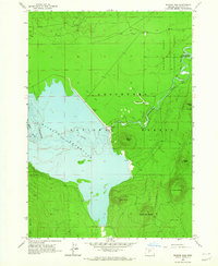
1963 Map of Wickiup Dam
USGS Topo · Published 1965About this map
Wickiup Dam anchors this mid-century landscape, holding back the massive Wickiup Reservoir along the Deschutes River. This 1963 field check records the hydrological infrastructure of the era, including a gaging station and a spillway with an elevation of 4338 feet. The surrounding terrain is defined by a series of volcanic landmarks, from Wickiup Butte to Davis Mountain, which rise above the heavily forested lands of the Deschutes National Forest.
Find a feature on this map
23 named features on this map. Tap any name to fly to it.
Don’t see what you’re looking for? This feature index may not catch every label — zoom into the map to look around manually.
Map Details
Editions of this 1963 Wickiup Dam Map
3 editions found
Other maps of this area

1930 · Maiden Peak
USGS Topo · 1:125,000

1934 · Maiden Peak
USGS Topo · 1:125,000

1955 · Crescent
USGS Topo · 1:250,000

1957 · Crescent
USGS Topo · 1:250,000

1958 · Crescent
USGS Topo · 1:250,000

1963 · Round Mountain
USGS Topo · 1:24,000

1963 · Hamner Butte
USGS Topo · 1:24,000

1963 · La Pine
USGS Topo · 1:24,000

1963 · Masten Butte
USGS Topo · 1:24,000
1963 · Pistol Butte
USGS Topo · 1:24,000