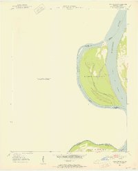
1951 Map of Wickliffe SW
USGS Topo · Published 1953About this map
The Mississippi River dominates this mid-century survey, defining the shifting border between Missouri and Kentucky. Centered on the massive Islands Nos 2 3 & 4, the map illustrates a complex riparian environment where the main channel meets secondary waterways like the Chute of Islands 2 3 & 4. The terrain is characterized by the hydraulic action of the river, notably at Lucas Bend and within the interior of the islands where Tennessee Slough and No 4 Lake are situated. Further south, the map captures a portion of Wolf Island No 5 as it sits near the tri-county junction of Hickman, Carlisle, and Mississippi counties. This 1951 documentation provides a precise record of the river's path and landforms before subsequent decades of erosion and channel management altered these alluvial features.
Find a feature on this map
13 named features on this map. Tap any name to fly to it.
Don’t see what you’re looking for? This feature index may not catch every label — zoom into the map to look around manually.
Map Details
Editions of this 1951 Wickliffe SW Map
3 editions found
Other maps of this area

1939 · Wickliffe
USGS Topo · 1:62,500

1939 · Charleston
USGS Topo · 1:62,500

1939 · Hickman
USGS Topo · 1:62,500

1939 · Bayouville
USGS Topo · 1:62,500

1951 · Oakton
USGS Topo · 1:24,000

1951 · Wolf Island
USGS Topo · 1:24,000

1951 · Wickliffe SW
USGS Topo · 1:24,000

1951 · Arlington
USGS Topo · 1:24,000

1951 · Wickliffe
USGS Topo · 1:24,000

1952 · Wickliffe
USGS Topo · 1:62,500