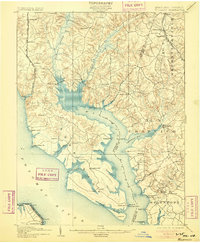
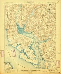
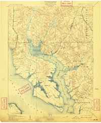
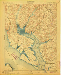
1902 Map of Wicomico
USGS Topo · Published 1905About this map
Ludlow Ferry and the broad waters of the Wicomico River define this coastal landscape at the turn of the century. The map illustrates a transitional period for Southern Maryland commerce, where tidewater navigation and early rail lines competed for the region's tobacco and agricultural trade. The Philadelphia Wilmington and Baltimore R. R. and the Washington and Potomac R. R. cut through the interior, while deep-water landings like Flowdens Wharf and Lancaster Wharf remained vital links to the Potomac River.
Find a feature on this map
69 named features on this map. Tap any name to fly to it.
Don’t see what you’re looking for? This feature index may not catch every label — zoom into the map to look around manually.
Map Details
Editions of this 1902 Wicomico Map
5 editions found

Other maps of this area

1889 · Fredericksburg
USGS Topo · 1:125,000

1890 · Mt. Vernon
USGS Topo · 1:125,000

1891 · Mt. Vernon
USGS Topo · 1:125,000

1892 · Leonardtown
USGS Topo · 1:62,500

1892 · Fredericksburg
USGS Topo · 1:125,000

1892 · Prince Frederick
USGS Topo · 1:62,500

1892 · Brandywine
USGS Topo · 1:62,500

1892 · Piney Point
USGS Topo · 1:62,500

1892 · Montross
USGS Topo · 1:62,500

1894 · Wicomico
USGS Topo · 1:62,500