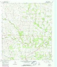
1965 Map of Wied
USGS Topo · Published 1987About this map
The small rural community of Wied sits at the center of this Lavaca County landscape, which was characterized by cattle ranching and scattered agricultural homesteads in the mid-1960s. The area is defined by a dense network of winding waterways, including Smothers Creek, Ponton Creek, and Rocky Creek, which likely provided the necessary drainage and water sources for the region's livestock. Local life in this era revolved around institutions like the Vysehrad Sch and the Mount Olive church and settlement, while the Charlottenburg Cem serves as a marker of the area's early German-Texan heritage. An Old RR Grade cutting through the terrain southeast of Worthing points to an earlier era of rail transportation that once connected these isolated pockets of the county. In the southeast corner near Mont, the map records several gas wells and a Quarry, indicating the transition from purely agricultural land use to early industrial resource extraction.
Find a feature on this map
17 named features on this map. Tap any name to fly to it.
Don’t see what you’re looking for? This feature index may not catch every label — zoom into the map to look around manually.
Map Details
Editions of this 1965 Wied Map
2 editions found
Other maps of this area

1901 · Flatonia
USGS Topo · 1:125,000

1919 · Schulenburg
USGS Topo · 1:62,500

1953 · Seguin
USGS Topo · 1:250,000

1958 · Seguin
USGS Topo · 1:250,000

1962 · Hallettsville
USGS Topo · 1:24,000

1963 · Yoakum
USGS Topo · 1:24,000

1963 · Sweet Home
USGS Topo · 1:24,000

1964 · Ezzell
USGS Topo · 1:24,000

1965 · Wied
USGS Topo · 1:24,000

1965 · Komensky
USGS Topo · 1:24,000