
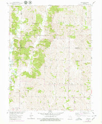
1953 Map of Wien
USGS Topo · Published 1955About this map
Wien serves as the primary hub of this North Central Missouri landscape, situated within the Bee Branch township where the rural topography is defined by the winding course of the Mussel Fork. This mid-century survey documents a dense network of early social infrastructure, notably the distributed rural school system featuring High Hill Sch, Hayes Sch, and Wilson Sch. The presence of St Marys Cem and High Hill Ch highlights the importance of these small community centers to the local genealogy of Chariton and Macon counties. The terrain is intricately carved by numerous waterways like Brush Creek and the multiple branches of Bee Creek, illustrating a landscape where transport and settlement patterns were dictated by the drainage of the Missouri River Basin. This survey was conducted as part of the Department of the Interior program for the development of the basin, capturing the area just after aerial photography was integrated into the mapping process in the late 1940s.
Find a feature on this map
29 named features on this map. Tap any name to fly to it.
Don’t see what you’re looking for? This feature index may not catch every label — zoom into the map to look around manually.
Map Details
Editions of this 1953 Wien Map
2 editions found
Other maps of this area

1937 · Elmer
USGS Topo · 1:48,000

1942 · Elmer
USGS Topo · 1:62,500

1949 · Bucklin
USGS Topo · 1:24,000

1950 · Bucklin
USGS Topo · 1:24,000

1950 · New Cambria West
USGS Topo · 1:24,000

1953 · Moberly
USGS Topo · 1:250,000

1953 · Marceline
USGS Topo · 1:24,000

1953 · Prairie Hill
USGS Topo · 1:24,000

1953 · Lagonda
USGS Topo · 1:24,000

1953 · Bynumville
USGS Topo · 1:24,000