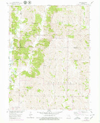
1953 Map of Wien
USGS Topo · Published 1979About this map
The settlement of Wien serves as a focal point in this 1953 landscape, situated at the crossroads of northern Missouri’s rolling prairie and forested creek bottoms. This map reveals a community deeply rooted in its local institutions, evidenced by the numerous country schools and churches that dotted the countryside before mid-century consolidation. Researchers can trace the locations of the High Hill Sch and Miller Sch, along with the St Marys Cem which anchors the Catholic community at Wien. The terrain is defined by the winding course of Mussel Fork and its many tributaries, including Bee Branch and West Branch. These watercourses dictated the early settlement patterns and road networks across the Linn and Macon county lines, creating a patchwork of small family farms and woodlots.
Find a feature on this map
25 named features on this map. Tap any name to fly to it.
Don’t see what you’re looking for? This feature index may not catch every label — zoom into the map to look around manually.
Map Details
Editions of this 1953 Wien Map
2 editions found
Other maps of this area

1937 · Elmer
USGS Topo · 1:48,000

1942 · Elmer
USGS Topo · 1:62,500

1949 · Bucklin
USGS Topo · 1:24,000

1950 · Bucklin
USGS Topo · 1:24,000

1950 · New Cambria West
USGS Topo · 1:24,000

1953 · Moberly
USGS Topo · 1:250,000

1953 · Marceline
USGS Topo · 1:24,000

1953 · Prairie Hill
USGS Topo · 1:24,000

1953 · Lagonda
USGS Topo · 1:24,000

1953 · Wien
USGS Topo · 1:24,000