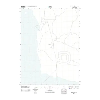
2010 Map of Wig Mountain
USGS Topo · Published 2010About this map
Wig Mountain dominates this portion of the Utah desert, its topographic contours rising sharply above the surrounding flats in the Tooele County wilderness. This 2010 survey illustrates the remote character of the landscape, defined by expansive open terrain and limited infrastructure. Transportation is restricted to a few established corridors, primarily Skull Valley Rd and N Wig Mountain Rd, which navigate the periphery of the central mountain formation. The map reveals a specialized land-use pattern, featuring geometric restricted-access perimeters that suggest the area's role in government or military operations within the Great Salt Lake Desert region. These man-made footprints contrast with the natural drainage patterns and the isolated elevation of the mountain itself.
Find a feature on this map
3 named features on this map. Tap any name to fly to it.
Don’t see what you’re looking for? This feature index may not catch every label — zoom into the map to look around manually.
Map Details
Editions of this 2010 Wig Mountain Map
This is the sole edition of this map. No revisions or reprints were ever made.
Other maps of this area

1885 · Tooele Valley
USGS Topo · 1:250,000

1953 · Tooele
USGS Topo · 1:250,000

1954 · Wig Mtn SW
USGS Topo · 1:24,000

1954 · Dugway Proving Ground NE
USGS Topo · 1:24,000

1954 · Camels Back Ridge NW
USGS Topo · 1:24,000

1954 · Dugway Proving Ground NW
USGS Topo · 1:24,000

1954 · Wig Mtn NW
USGS Topo · 1:24,000

1955 · Tabbys Peak
USGS Topo · 1:24,000

1955 · Wig Mtn
USGS Topo · 1:24,000

1955 · Wig Mtn NE
USGS Topo · 1:24,000