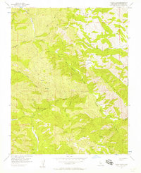
1956 Map of Wilcox Ridge
USGS Topo · Published 1957About this map
Wilcox Ridge anchors this 1956 survey of the Diablo Range, where deep canyons and isolated livestock operations defined the landscape of western Stanislaus County. The rugged topography is etched with numerous watercourses, including the North Fork Orestimba Creek and Salado Creek. Human activity is concentrated around family holdings such as the Isom Ranch, which features a remote Landing Strip, and the Miller Ranch further south near Days Pass.
Find a feature on this map
27 named features on this map. Tap any name to fly to it.
Don’t see what you’re looking for? This feature index may not catch every label — zoom into the map to look around manually.
Map Details
Editions of this 1956 Wilcox Ridge Map
3 editions found
Other maps of this area

1916 · Patterson
USGS Topo · 1:31,680

1919 · Orestimba
USGS Topo · 1:62,500

1919 · Orestimba Creek
USGS Topo · 1:31,680

1920 · Pacheco Pass
USGS Topo · 1:62,500

1921 · Gilroy Hot Springs
USGS Topo · 1:62,500

1938 · Mt. Boardman
USGS Topo · 1:62,500

1939 · Gilroy Hot Springs
USGS Topo · 1:62,500

1940 · Gilroy Hot Springs
USGS Topo · 1:62,500

1940 · Pacheco Pass
USGS Topo · 1:62,500

1941 · Orestimba
USGS Topo · 1:62,500