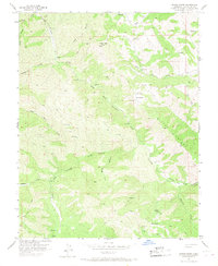
1956 Map of Wilcox Ridge
USGS Topo · Published 1968About this map
Wilcox Ridge dominates this interior portion of the Diablo Range, where a network of steep canyons and seasonal creeks defines the ranching landscape of mid-century Stanislaus County. The map captures a transition in backcountry utility, noting the Mikes Peak Lookout as an abandoned site while documenting active ranching operations at Isom Ranch and Miller Ranch. Transport through this challenging terrain is limited to a spiderweb of Jeep Trails and a small Landing Strip near the Isom property, highlighting the isolation of these uplands. Water management is critical in this environment, evidenced by scattered Reservoir labels and the winding course of North Fork Orestimba Creek. A single Shaft located in North Canyon suggests historical prospecting or mining activity, providing a specific point of interest for researchers of the region's industrial past and land use patterns before modern development reached the foothills.
Find a feature on this map
28 named features on this map. Tap any name to fly to it.
Don’t see what you’re looking for? This feature index may not catch every label — zoom into the map to look around manually.
Map Details
Editions of this 1956 Wilcox Ridge Map
3 editions found
Other maps of this area

1916 · Patterson
USGS Topo · 1:31,680

1919 · Orestimba
USGS Topo · 1:62,500

1919 · Orestimba Creek
USGS Topo · 1:31,680

1920 · Pacheco Pass
USGS Topo · 1:62,500

1921 · Gilroy Hot Springs
USGS Topo · 1:62,500

1938 · Mt. Boardman
USGS Topo · 1:62,500

1939 · Gilroy Hot Springs
USGS Topo · 1:62,500

1940 · Gilroy Hot Springs
USGS Topo · 1:62,500

1940 · Pacheco Pass
USGS Topo · 1:62,500

1941 · Orestimba
USGS Topo · 1:62,500