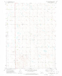
1973 Map of Wild Horse Spring
USGS Topo · Published 1977About this map
Wild Horse Spring serves as a historical focal point in this portion of Perkins County, which is defined by the undulating topography of the High Plains. The landscape is marked by numerous Wells and depressions typical of the region's cattle-ranching and agricultural character. North of the small settlement area of Grant, the map reveals a sparsely populated section of the Nebraska panhandle where education and community were centered at places like the Trinity Sch. Modern infrastructure is represented by a local Golf Course and a Radio Tower, while the drainage of Roscoe Draw cuts through the northern sections of the map. Fine dashed lines across the terrain provide a rare recorded look at fence and field boundaries as they existed during the early 1970s, illustrating the partition of the open range.
Find a feature on this map
10 named features on this map. Tap any name to fly to it.
Don’t see what you’re looking for? This feature index may not catch every label — zoom into the map to look around manually.
Map Details
Editions of this 1973 Wild Horse Spring Map
This is the sole edition of this map. No revisions or reprints were ever made.
Other maps of this area

1897 · Ogallala
USGS Topo · 1:125,000

1900 · Ogallala
USGS Topo · 1:125,000

1954 · McCook
USGS Topo · 1:250,000

1954 · North Platte
USGS Topo · 1:250,000

1956 · North Platte
USGS Topo · 1:250,000

1957 · North Platte
USGS Topo · 1:250,000

1957 · McCook
USGS Topo · 1:250,000

1958 · McCook
USGS Topo · 1:250,000

1961 · Brandon NE
USGS Topo · 1:24,000

1961 · Brandon SE
USGS Topo · 1:24,000