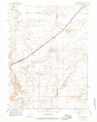
1964 Map of Wildcat Butte
USGS Topo · Published 1968About this map
Wildcat Butte and the surrounding high plains of Uinta and Sweetwater Counties reveal an industrial landscape shaped by energy extraction during the mid-1960s. The presence of a Refinery near the intersection of Church Butte Road and Mud Spring Road highlights the area's role as a processing hub, supported by a network of infrastructure including a pipeline and numerous extraction sites like Gas Well 6828 and Gas Well 6918.
Find a feature on this map
22 named features on this map. Tap any name to fly to it.
Don’t see what you’re looking for? This feature index may not catch every label — zoom into the map to look around manually.
Map Details
Editions of this 1964 Wildcat Butte Map
This is the sole edition of this map. No revisions or reprints were ever made.
Other maps of this area

1954 · Ogden
USGS Topo · 1:250,000

1954 · Rock Springs
USGS Topo · 1:250,000

1958 · Ogden
USGS Topo · 1:250,000

1958 · Rock Springs
USGS Topo · 1:250,000

1960 · Ogden
USGS Topo · 1:250,000

1961 · Granger
USGS Topo · 1:24,000

1962 · Rock Springs
USGS Topo · 1:250,000

1964 · Butcher Knife Draw
USGS Topo · 1:24,000

1964 · Antelope Knoll
USGS Topo · 1:24,000
1964 · Needle Reservoir
USGS Topo · 1:24,000