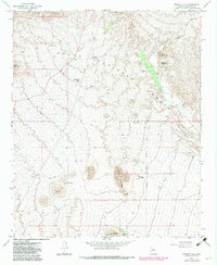
1965 Map of Wildcat Hill
USGS Topo · Published 1982About this map
Browns Ranch stands as a focal point in this 1960s survey of the high desert northeast of Phoenix. The landscape is defined by the transitions between prominent peaks such as Wildcat Hill, Granite Mountain, and Fraesfield Mountain, all set within the expansive reach of the Tonto National Forest. Water management is a critical theme, evidenced by numerous isolated water resources including Bootlegger Tank, Black Hill Tank, and the winding course of Blue Wash. A network of jeep trails provides the primary means of traversal through this arid terrain, connecting scattered prospects that suggest historical mining interest in the area. The map also records modern infrastructure of the era, such as a prominent Radio Tower situated on a high point, alongside traditional ranching features, reflecting the multi-use nature of the public land during this period of Arizona's development.
Find a feature on this map
18 named features on this map. Tap any name to fly to it.
Don’t see what you’re looking for? This feature index may not catch every label — zoom into the map to look around manually.
Map Details
Editions of this 1965 Wildcat Hill Map
3 editions found
Other maps of this area

1904 · Camelback
USGS Topo · 1:62,500

1904 · Ft. McDowell
USGS Topo · 1:62,500

1906 · Camelsback
USGS Topo · 1:62,500

1906 · Ft. McDowell
USGS Topo · 1:62,500

1930 · Cave Creek
USGS Topo · 1:125,000

1939 · Cave Creek
USGS Topo · 1:125,000

1954 · Mesa
USGS Topo · 1:250,000

1957 · Mesa
USGS Topo · 1:250,000

1958 · Mesa
USGS Topo · 1:250,000

1960 · Mesa
USGS Topo · 1:250,000