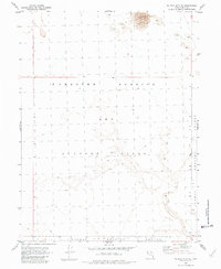
1954 Map of Wildcat Mtn SE
USGS Topo · Published 1981About this map
Dugway Proving Ground and the Wendover Bombing and Gunnery Range dominate this mid-century topographic record of the Tooele County desert. Compiled from aerial photographs taken in 1953, the map shows a landscape defined almost entirely by military boundaries and natural terrain. The northeastern corner of the quadrangle is marked by prominent Sand Dunes, providing a stark contrast to the vast, open expanse utilized for defense operations during the early Cold War era. Surveyed by plane-table methods in 1954, the map preserves the exact alignment of township and range lines across this restricted government land, where few human-made features exist beyond the survey monuments and military perimeters.
Find a feature on this map
7 named features on this map. Tap any name to fly to it.
Don’t see what you’re looking for? This feature index may not catch every label — zoom into the map to look around manually.
Map Details
Editions of this 1954 Wildcat Mtn SE Map
5 editions found
Other maps of this area

1953 · Tooele
USGS Topo · 1:250,000

1954 · Wig Mtn SW
USGS Topo · 1:24,000

1954 · Wildcat Mtn
USGS Topo · 1:24,000

1954 · Granite Peak
USGS Topo · 1:24,000

1954 · Wildcat Mtn SE
USGS Topo · 1:24,000

1954 · Dugway Proving Ground NW
USGS Topo · 1:24,000

1954 · Wig Mtn NW
USGS Topo · 1:24,000

1955 · Tooele
USGS Topo · 1:250,000

1973 · Wildcat Mountain SW
USGS Topo · 1:24,000

1973 · Wildcat Mountain NW
USGS Topo · 1:24,000