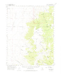
1960 Map of Wildcat Peak
USGS Topo · Published 1975About this map
Toquima Cave and the high elevations of the Toiyabe Range define this mid-century survey of the Nevada interior. The landscape transitions from the broad Big Smoky Valley in the west to the deeply incised drainages of the Toiyabe National Forest. Human presence is marked by isolated outposts like Indian Ranch and the Bronco Mine, alongside a network of seasonal water sources such as Petes Spring and Turquoise Spring. The map documents a rugged transit network of primitive routes, including the Jeep Henry Meyer Trail and the passage through Petes Summit. This terrain is characterized by a high density of named canyons, including Stoneberger Canyon, North Fork Canyon, and South Fork Canyon, which reveal the complex drainage patterns feeding into the valley floor. Researchers will find numerous prospects and springs that reflect the region's mining and ranching history during the postwar era.
Find a feature on this map
53 named features on this map. Tap any name to fly to it.
Don’t see what you’re looking for? This feature index may not catch every label — zoom into the map to look around manually.
Map Details
Editions of this 1960 Wildcat Peak Map
2 editions found

Other maps of this area

1907 · Tonopah
USGS Topo · 1:250,000

1908 · Tonopah
USGS Topo · 1:250,000

1926 · Roberts Mountains
USGS Topo · 1:250,000

1929 · Roberts Mountains
USGS Topo · 1:250,000

1955 · Millett
USGS Topo · 1:250,000

1956 · Millett Ranch
USGS Topo · 1:62,500

1956 · Austin
USGS Topo · 1:62,500

1956 · Tonopah
USGS Topo · 1:250,000

1959 · Tonopah
USGS Topo · 1:250,000

1959 · Millett
USGS Topo · 1:250,000