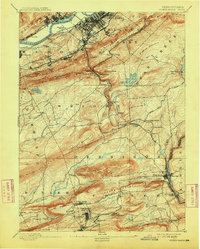
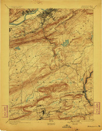
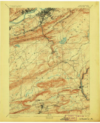
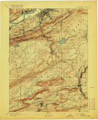
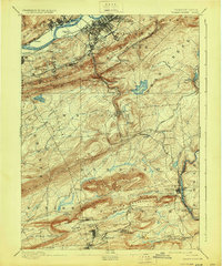
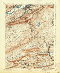
1894 Map of Wilkes-Barre
USGS Topo · Published 1913About this map
The Susquehanna River and its industrial valley dominate the northern edge of this landscape, where the heavy infrastructure of the late nineteenth-century coal region is most apparent. Extensive rail networks, including the Lehigh Valley R. R. and the C. R. R. of N. J., weave through the valley floor to serve high-density settlements like Wilkes Barre, Nanticoke, and Ashley. Beyond the immediate river corridor, the terrain rises sharply into the ridge-and-valley province, marked by prominent features such as Wyoming Mountain and Penobscot Mountain.
Find a feature on this map
87 named features on this map. Tap any name to fly to it.
Don’t see what you’re looking for? This feature index may not catch every label — zoom into the map to look around manually.
Map Details
Editions of this 1894 Wilkes-Barre Map
8 editions found


Other maps of this area

1889 · Scranton
USGS Topo · 1:62,500

1889 · Hazleton
USGS Topo · 1:62,500

1891 · Wilkesbarre
USGS Topo · 1:62,500

1891 · Hazleton
USGS Topo · 1:62,500

1891 · Scranton
USGS Topo · 1:62,500

1891 · Harveys Lake
USGS Topo · 1:62,500

1892 · Mahanoy
USGS Topo · 1:62,500

1893 · Hazleton
USGS Topo · 1:62,500

1893 · Harvey Lake
USGS Topo · 1:62,500

1893 · Pittston
USGS Topo · 1:62,500