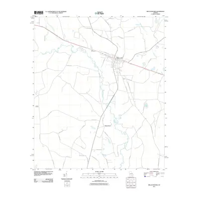
2011 Map of Willacoochee
USGS Topo · Published 2011About this map
Willacoochee serves as the primary hub of activity in this south Georgia landscape, situated at the junction of rail and road corridors during the early twenty-first century. The surrounding terrain is defined by the winding course of the Alapaha River, which meanders southward through the center of the quadrangle, joined by the Willacoochee River in the northwest. Local history and genealogy are anchored by specific landmarks such as the Death Age Cemetery and Gaskins Cemetery, alongside the small community of Bannockburn. The map illustrates a network of rural routes like Coffee Rd and Springhead Church Rd that connect isolated farms and timberlands. Significant water features including Ruffin Creek, Pudding Creek, and the swampy expanse of Long Bay further characterize the lowland environment of Atkinson County.
Find a feature on this map
42 named features on this map. Tap any name to fly to it.
Don’t see what you’re looking for? This feature index may not catch every label — zoom into the map to look around manually.
Map Details
Editions of this 2011 Willacoochee Map
This is the sole edition of this map. No revisions or reprints were ever made.
Other maps of this area

1953 · Waycross
USGS Topo · 1:250,000

1958 · Waycross
USGS Topo · 1:250,000

1972 · Tenmile Bay
USGS Topo · 1:24,000

1972 · Kirkland
USGS Topo · 1:24,000

1972 · Willacoochee
USGS Topo · 1:24,000

1972 · Lax
USGS Topo · 1:24,000

1972 · Henderson Still
USGS Topo · 1:24,000

1972 · Mora
USGS Topo · 1:24,000
1977 · Mora
USGS Topo · 1:24,000
1977 · Alapaha
USGS Topo · 1:24,000